Today is the World Wetlands Day. Why would such a day matter for you? It may matter indirectly but for many it is a direct source of livelihood. Today’s observation is aimed at raising global awareness on the important role wetlands play for humanity first and second, for our planet earth.
The observation of the World Wetlands Day was a ratification of a convention reached in Ramsar Iran in the year 1971 and its adaption was done symbolically at the shores of the Caspian Sea. Wetlands were the first ecosystem to receive international attention through the “Convention on Wetlands of International Importance especially as Habitats for Waterfowls”. Kenya ratified this convention in 1990 and has since designated Lakes Nakuru and Naivasha as Wetlands of international importance (Ramsar Sites) in accordance with the requirements thereof.
But what exactly are wetlands?
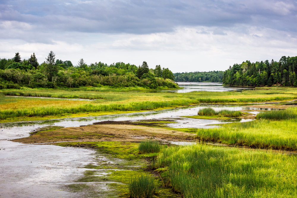
Simply put, wetlands occur where water meets land. For Kenyans, this is most familiarly defined when we think of the coastal mangroves, and marshes, rivers like the Ewaso Nyiro in Kajiado and lakes such as the historically famous Lake Victoria.
We also have deltas, floodplains and our rice-fields of Mwea, and even coral reefs when we talk about Kisite Mpunguti at the Coast of Mombasa. Generally wetlands exist in every country and in every climatic zone, from the polar regions to the tropics, and from high altitudes to dry regions.
Why are wetlands important?
Wetlands are among the most productive ecosystems on earth. They allow interaction between water, soil, vegetation and light all the year round or during a greater part of the year. The depth of the water is such that it allows photosynthesis to occur, making wetlands productive life-supporting ecosystems.
It is this association of water, light, soil and plants that typifies various wetlands of Kenya which are famous for their spectacular avifauna and fisheries resources. These areas may incorporate riparian and coastal zones adjacent to the wetlands, and islands or bodies of marine water deeper than six metres at low tide lying within the wetlands.
According to the Kenya National Environment Action Plan (NEAP), prepared in 1994, a substantial proportion of Kenya’s water resources is found in wetlands, which cover 2 to 3% of the country’s surface area. These wetlands are diverse in type and distribution.
Some of the larger wetlands of Kenya include the shallow lakes Nakuru, Naivasha, Magadi, Kanyaboli, Jipe, Chala, Elmentaita, Baringo, Ol’Bolossat, Amboseli and Kamnarok; the edges of Lake Victoria and Lorian, Saiwa, Yala, Shompole swamps; Lotikipi (Lotagipi) and Kano plains; Kisii valley bottoms and Tana Delta; and coastal wetlands including the mangroves swamps, sandy beaches, sea grassbeds and coral reefs.
The list also includes various seasonal and temporary wetlands that occur where internal drainage allows water to collect in some seasons or in some years. These are found all over the country, including rock pools and springs in the southern part of Nairobi, west of Ngong Hills, and at Limuru. Man-made wetlands include the dams, primarily meant for hydropower and water supply, and wetlands created for purposes of wastewater treatment.
The Kenyan wetlands play a fundamental ecological role and have potential as resources of great economic, cultural and scientific value. Among the critical values are:
- Provision of critical habitats for a wide range of flora and fauna. Their biodiversity includes aquatic plants, fish, herbivores and avifauna of resident and migratory birds;
- Important sources of water for human consumption, agriculture and watering of livestock.
- Recharging of wells and springs that are often the only source of wa ter to some rural communities,
- Livestock watering and for wildlife support systems.
- Recharging of aquifers, raising water tables thus making groundwater easily accessible as has been the case in Tana river corridor and in the Chyulu hills catchment area for Mzima springs and the Nol-Turesh water supply system.
- Provision of economic benefits through fisheries and generation of products such as fuelwood, building material, medicine, honey and various types of natural foods;
- Necessary grazing areas as they are the only sources of water and pasture/fodder for the pastoral communities during drought in the ASALs;
- Serving a wide variety of ecosystem functions including flood control, water purification, shoreline stabilization and sequestration of carbon dioxide;
- They are areas of great scenic beauty, tourist attraction, recreation sites for game and birds watching, swimming, photography and sailing;
- Harness great potential for multiple uses (including agricultural) so long as precautionary measures are taken for sustainable development.
To be a part of the GoGreen Agenda, join the Go Green Facebook page today and learn more about how to make our world a better place. Will you join us?
By Cathrine Khasoa
Cathrine, is passionate about the environment and how it affects social and economic landscapes of the community. She serves as Lead for Public Relations and Communication at Optiven Group.


